


Walking
Drimnin offers a wide variety of walks for visitors of all activity levels. For ease of reference, the directions all start (unless otherwise indicated) from the Drimnin jetty at the end of the public road and enter the Estate by the track (50 meters before the jetty) which has a public footpath sign.
The best map is the Ordnance Survey Explorer series (1:25,000 or 2 ½ inches to the mile) Sheet 383 Morvern and Lochaline. Copies of this map, and the equivalent Mull maps, are available for sale on the Estate. Or Alternatively click the 'View larger map' icon on Google Map link to show the routes. Routes overlap so you will need to turn some layers off to view specific routes (please note we recommend taking a hardcopy map with you, mobile coverage may not be available or you may lose battery power on your phone)
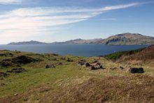
3.6km Circular Walk, taking in the chapel, boathouse and the McLean Tomb.
The first part of the walk as far as the chapel bears blue arrows on marker posts.
From the jetty follow the public road for 50 metres, take the first left up a track (leading away from the shore) and take the left fork in the track, follow this for about half a mile. Pass through two metal gate and follow the track as it bends left, then turn right alongside a burn just before an isolated house (known as the Hermitage). Pass through another metal gate and continue along this track to a T-junction.
* Detour from the circular route to visit the Chapel. Turn left through a gate, and then turn almost immediately right through the right hand of two gates and follow a track alongside a reedy field. The chapel is on the rocky outcrop reached by turning left up a stony track near the end of the track. The old walled garden with newly planted orchard is just (Please keep the orchard gate closed)
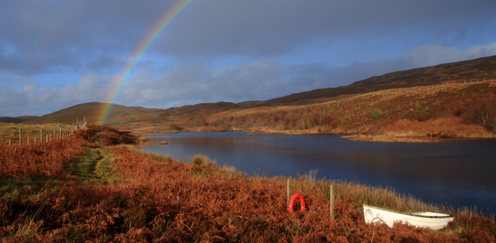
* Detour from the circular route to visit the boathouse.Turn left through the gate and instead of going through the right hand of the two gates, go through the left hand gate and follow the track ahead to the coast, boathouse and jetty, with a peninsula beyond that offers glorious views back towards the chapel and a fine spot for a picnic.
Rejoin circular route. Retrace your steps to where you detoured, continue along the track passing through the woods, pass through a metal stock gate and follow the track up between two fields. At the top of the field turn left through another metal stock gate (Do not go through the cast iron gates with stone gateposts). Continue straight ahead (for about 50m) and at the t-junction continue straight on and up the rise until reaching stone wall running along the left hand side of the road, continue for approx 50 meters.
*Detour from the circular route to visit the McLean Tomb. Using one of the gaps cross through the wall on the left and follow a less well defined path up the small hill to the McLean Tomb.
Rejoin the circular route. Leave the estate track at this point and follow the footpath marker up the hill (bearing slightly right), half way up the hill pass through the tall wooden flap gate (beside the distillery cooling pond) and head uphill on the footpath between the gorse thickets (with the large green sheds a 100m to your right). On reaching a track bear right and follow the track (do not take the right turn with a cattle grid and distillery sign). On meeting the main Estate track (just to the left of the Lodge) bear left and follow the track (pass by a left turn marked Achleanan Farm), take the next right hand fork leading downhill. Leave this track through one of the double set of gates on the left and head downhill, back towards the start of the walk, the public road and the jetty.
Doirlinn

Six miles each way, easy walking
The Estate track from Drimnin village to Doirlinn, constructed as a work creation project at the beginning of the twentieth century, offers easy walking and spectacular views of Mull, the Atlantic, Ardnamurchan, Rum, Loch Sunart and the mountains beyond.
The early stages bear green waymarkers. After starting on the Estate track, take the right hand fork after 50 metres and continue up the rise and bear left joining the main Estate track. Continue on this track until reaching the signs for the distillery and Doirlinn which you should follow to your right, immediately before the stone pillars which mark the entrance to Drimnin House. A track to the distillery will join from the left (near cattlegrid), but continue straight ahead up the rise. At this point Loch Sunart will come into view. continue through the dear gate and follow the track all the way to Doirlinn. Return by the same route.
Auliston and Waterfall
One and three-quarter miles each way, easy walking except down the waterfall which requires care.
Start as for Doirlinn, go through the deer fence onto the open hill and after a further mile the track crosses a burn before zig-zagging up a steep hill just before a plantation of conifers. Turn off the track to the left after the burn and before the zig-zags on the hill, cross the field heading north and go through the gate.
For the waterfall bear left and follow the burn down on the right hand bank, being very careful as it becomes steeper.
For the ruins of Auliston village keep straight ahead down the ridge overlooking the plantation and the village soon comes into view.
These two variants can be combined, down one way and up the other, or walkers can continue to Auliston Point below the plantation and return up through the plantation by entering a large gate with stile half way along the bottom of the plantation (not the first stile along the bottom). The track up through the plantation emerges onto the main estate track above the zig-zags.
Drimnin Chapel

Bear left at the fork in the Estate track 50 metres from the public road and follow this for about half a mile. Turn right alongside a burn just before the isolated house, known as the Hermitage, and continue along this track to a T-junction. Turn left through a gate, and then turn almost immediately right through a second gate and follow a track alongside a reedy field. The chapel is on the rocky outcrop reached by turning left up a stony track near the end of the track. The old walled garden, which has now been replanted with fruit trees is just beyond. If, instead of turning into the reedy field, walkers follow the track ahead through another gate towards the coast the boathouse and jetty is soon reached, with a peninsula beyond that offers glorious views and a fine place for a picnic.
The path bears brown waymarkers
Achleanan and Lochan na Buick
One mile each way, easy walking, steep in places.
Bear right at the fork in the Estate track as if for Doirlinn. Shortly after two tracks merge another goes off to the right marked Achleanan and the farm. Follow this past the modern agricultural building and up the hill to Achleanan. Pass through the gate in front of Achleanan and turn right after the next gate until the track crosses a grassy field. Go through the gate at the far side, and take the gate on the left immediately after this. Follow the fenceline up the slope to your right. This will bring you out on the ridge above the lochan, which has a bird-watching hide. Trout fishing is available on the lochan with a permit available from the Estate office.
Note: please avoid this walk during the lambing season
Mungosdail Forest, Beinn Bhuidhe, Barr and Doirlinn
A magnificent 16 mile round trip, two and a half miles to top of forest, easy walking; more difficult down to Barr; half a mile of rough walking to Doirlinn; and an easy track back from Doirlinn.
From the pier, return along the public road, cross the bridge over the Mungosdail river (to the Lochaline side) and after 50 metres turn left up the Estate track carrying a public footpath sign to Barr. Follow this track, bearing right at the waterworks where it divides and continue up passing the Mungosdail farmhouse to the gate into the Mungosdail Forest (with pedestrian gate). Enter the forest and proceed up the track through a further gate. After another half mile look out for a footpath sign off to the left and follow this. The footpath winds all the way up through the forest to a gate at the top. Go through the gate and straight ahead up to the ridge. Keep your eyes peeled for St Columba's Stone. From here you can (a) descend into Coire Bhuidhe below and enter the Barr Forest through a gate, (b) climb to the right to the summit of Beinn Bhuidhe, or (c) turn left and circle around the east of Lochan Crois-Bheinn onto the open hill and back to Drimnin. The route through a felled section of the Barr Forest is reported to be challenging, but if surmounted offers a further route along the good coastal footpath back to Doirlinn after half a mile of rough walking before Doirlinn. This can be combined with the reverse of the Doirlinn walk to produce a circular route of some 12 miles offering an exceptional variety of terrain and splendid views.
When undertaking any of these walks please observe the Scottish Countryside access code
which is based on three key principles
• Respect the interests of others.
• Care for the environment.
• Take responsibility for your own actions.
For more information visit:
https://www.outdooraccess-scotland.scot/practical-guide-all
Gallery


